|
|
|
賴比瑞亞 (Liberia) 的獨立:1847年7月26日
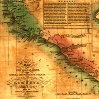
在1822年,傑弘帝‧艾許曼 (Jehundi
Ashman) 牧師為取得西非梅蘇拉多角 (Cape
Mesurado) 的一塊土地作為殖民地,與原住民進行談判。這個殖民地後來變成那些得到自由的非裔美人、從西印度群島與奴隸船上被釋放的奴隸,以及許多原住民的家鄉。到了1847年,約瑟夫‧詹金斯‧羅伯茲成為該殖民地的領袖,並且覺得賴比瑞亞應該已經準備好獨立了。直到今日,賴比瑞亞雖然還是一個國家,仍然得處理非裔美人後代與當地原住民部落之間的衝突。你以前有沒有聽過賴比瑞亞呢?看看你能不能在西非的地圖上找到它呢?
In 1822, Reverend Jehundi Ashman led the settlement effort and negotiated with native people for a piece of land at Cape Mesurado. The colony grew as it became a home for freed African Americans, slaves released from the West Indies and slave ships, and many native tribal people. By 1847, Joseph Jenkins Roberts had become a leader in the colony and felt Liberia was ready for independence. Still a country today, Liberia deals with conflict between descendants of African Americans and indigenous tribes. Have you heard of Liberia before? See if you can find it on a map of West Africa.
 3/3 頁
3/3 頁

|