|
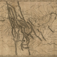
這是路易士和克拉克遠征隊的地圖,你知道達科達在哪裡嗎?

|
|
|
|
北達科達 (North
Dakota) 與南達科達 (South
Dakota) 於1889年11月2日加入聯邦了
經過長期對於首府究竟要設置在哪裡的爭論之後,達科達領土在1889年分裂為北部與南部兩個部分。同一年的11月2日,北達科達與南達科達都獲准加入美國,成為美國的第39州與第40州。這片廣大的領土是美國最後確定的領土之一。
第一批歐洲探險隊在1742年進入這個區域。在那個時候,至少有八個美國原住民部落在這裡定居,包括克洛族 (Crow) 、夏安族 (Cheyenne) ,以及達科達族 (聖提族 Santee、蘇族 Sioux) 。這些原住民對這兩個州的許多風俗習慣都有很深遠的影響。
After controversy over the location of a capital, the Dakota Territory was split in two and divided into North and South in 1889. Later that year, on November 2, North Dakota and South Dakota were admitted to the Union as the 39th and 40th states. This vast territory was one of the last American regions to be settled.
The first European explorers entered the region in 1742. At that time, at least eight Native American tribes populated the area, including the Crow, Cheyenne, and Dakota (Santee Sioux). The Native influence still characterizes many parts of the states.
 1/3
頁
1/3
頁
|