約翰昆西亞當斯擔任國務卿期間
John Quincy Adams as Secretary of State
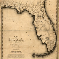
西班牙同意放棄佛羅里達州東、西兩岸的土地,美國則以豁免西班牙五百萬美金債務作為交換;西班牙也同意放棄密西西比河以東的土地,美國則以現在德州土地讓渡給西班牙管轄作為交換。
另外,亞當斯將美國領土邊界畫至太平洋岸、沿著42度線(加州的北方邊界)從墨西哥灣延伸到落磯山脈 – 這是一項了不起的外交成就。亞當斯也在1818年時與英格蘭訂定的條約中、完成了美國與加拿大邊界訂定的協議。
Spain agreed to give up both east and west Florida in exchange for America's forgiving of a Spanish debt of $5 million. Spain also agreed to surrender all claims to land east of the Mississippi River, and the U.S. did the same for what is now Texas, leaving that territory under Spanish control.
In addition, Adams got America's Western boundary drawn to the Pacific Ocean, from the Gulf of Mexico to the Rocky Mountains and along the 42nd parallel (the northern border of California) -- an extraordinary diplomatic accomplishment. Adams was also responsible for defining the U.S.-Canadian border as part of the Treaty of 1818 with England.
 3 / 3 頁

|