|
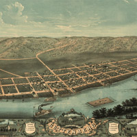
羅傑的一張地圖:1869年時愛荷華州克雷頓郡古登堡的鳥瞰圖

|
|
|
|
製作全景地圖 (Panoramic Map) 的藝術家阿爾柏特 ‧羅傑 (Albert Ruger) 去世了:1899年11月12日
全景地圖也被稱之為「鳥瞰圖」,因為地圖上的城鎮都是從斜上方的角度繪製而成的,就好像一隻鳥兒飛過城鎮時,在半里之處看著城鎮一般。全景地圖製作者並不擔心他們的地圖沒有確實的尺度,相反的,他們注重的是街道的形式、個別建築物,以及主要地形地物的特質標示。這張愛荷華州古登堡 (Guttenberg) 的全景圖就是一個很好的範例。
羅傑和另一個夥伴在1860年代後期設立了「商務平版印刷公司」 (Merchants
Lithographing Company) ,負責製作這些受歡迎的地圖。雖然現在的空中攝影以及沿著軌道環繞地球的衛星科技使得羅傑的全景圖有點落伍,但是他的全景圖卻能讓我們一窺美國城鎮過去的模樣。
Panoramic maps were also called "bird's-eye-view maps" because towns and cities were drawn as if viewed from above at a slanted angle, much like a bird might see from a half mile away as it flew by the town. Panoramic cartographers didn't worry so much about the exact scale of their drawings; they concentrated instead on illustrating street patterns, individual buildings, and major landscape features in perspective. This map of Guttenberg, Iowa, is a good example.
Ruger formed Merchants Lithographing Company with a partner in the late 1860s, producing many of these popular maps. Aerial photographs and earth-orbiting satellite mapping techniques of today have made Ruger's panoramic map-making techniques somewhat outdated, but his panoramic maps can give us a glimpse into the past of America's towns and cities.
 2/2 頁
2/2 頁

|