|
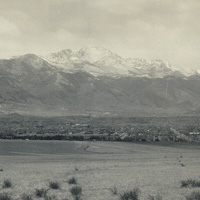
Rampart Range是前嶺(Front
Range)的一部分,
科羅拉多州境內的洛磯山脈

|
|
|
|
科羅拉多的洛磯山脈
許多人都知道洛磯山脈在北美洲的西部造就巨大的山系,起自加拿大,途經美國,終於墨西哥,足足有3,000英里長。但您知道高14,433英尺的厄爾柏山(Mount
Elbert)嗎?它是科羅拉多州境內最高的山脈,而且也是洛磯山脈的一部分。
洛磯山脈形成了大陸分水嶺(Continental
Divide),綿延不絕的山脊由北至南貫穿北美洲,因而導致水排入不同的河道並流向大陸的兩邊;最後,這些河流都會流入大西洋、太平洋及墨西哥灣。
1915年時,國會將科羅拉多境內的某部分多山地區指定為洛磯山國家公園,公園內最高的山為高14,256英尺的朗斯峰(Longs
Peak)。
Many people know that the Rocky Mountains make up an enormous chain of mountains in western North America that extends 3,000 miles from Canada through the United States to Mexico. But did you know that the tallest mountain in Colorado, part of the Rocky Mountains, is called Mount Elbert, which is 14,433 feet high?
The Rocky Mountains form the Continental Divide, the mountainous ridge that runs north to south along North America and causes water to drain in separate rivers flowing to different sides of the continent. Eventually, these rivers lead to the Atlantic and Pacific Oceans as well as the Gulf of Mexico.
In 1915, Congress designated some of this mountainous area in Colorado as Rocky Mountain National Park. The tallest mountain in this park is Longs Peak, which is 14,256 feet high.
 1/1 頁
1/1 頁

|